Creative Technology Integration
Innovating Reality. Empowering Business. Kami menghadirkan solusi teknologi imersif yang transformatif untuk meningkatkan keterlibatan pelanggan, efisiensi operasional, dan nilai bisnis Anda.
Augmented Reality
Active EngineDigital Twin
99.8% Sync0
Enterprise Clients
0
Industries Served
0
Global & National Projects
Membawa Masa Depan ke Hari Ini
Kami tidak sekadar membangun teknologi. Kami menciptakan pengalaman digital bermakna yang mengubah cara orang berinteraksi dengan masa depan.
PT Augmented Reality Indonesia (GoARGlobal) adalah perusahaan integrasi teknologi kreatif yang berspesialisasi dalam merancang dan mengembangkan pengalaman imersif mutakhir. Kami membantu korporasi, pemerintah, lembaga pendidikan, dan organisasi mempercepat transformasi digital mereka.
Dengan memadukan kreativitas tanpa batas, riset mendalam, dan teknologi canggih, solusi kami menghadirkan dampak terukur bagi pemasaran, pelatihan kerja, pameran, edukasi, hingga visualisasi data industri berskala besar.
Teknologi Imersif untuk Transformasi Bisnis
Augmented Reality (AR)
Menumpangkan informasi digital interaktif ke dunia nyata. Ideal untuk pemasaran produk, filter media sosial, edukasi interaktif, dan panduan pemeliharaan industri.
- Filter Instagram/TikTok & WebAR
- Buku & Kartu Interaktif AR
- Visualisasi Produk 3D Real-time
Virtual Reality (VR)
Membawa pengguna masuk sepenuhnya ke dunia digital 360° yang imersif. Cocok untuk pelatihan simulasi berisiko tinggi, tur virtual properti, dan hiburan.
- Simulasi Pelatihan Kerja (Safety/SOP)
- Virtual Tour & Showroom Properti
- Game & Edukasi VR Interaktif
Extended Reality (XR)
Gabungan teknologi AR, VR, dan Mixed Reality untuk interaksi mulus antara manusia, mesin, dan data di lingkungan virtual hibrida.
- Kolaborasi Tim Virtual Jarak Jauh
- Ruang Kerja Spasial Interaktif
- Aplikasi Pelatihan Lanjutan
Holographic Solutions
Menampilkan objek visual 3D melayang bebas tanpa memerlukan kacamata khusus. Sempurna untuk pameran premium, museum, dan peluncuran produk mewah.
- Hologram Pyramid Showcase
- Holographic Fan Display
- Interaksi Hologram Gerak Tangan
Interactive Visual Media
Media visual interaktif berukuran besar menggunakan layar sentuh raksasa, sensor gerak, atau proyeksi dinding/lantai untuk menciptakan ruangan interaktif.
- Immersive Room (Proyeksi 360°)
- Kiosk & Dinding Sentuh Interaktif
- Instalasi Pameran Berbasis Sensor
AI & Digital Twin
Mengintegrasikan AI dengan replika digital real-time dari aset fisik (pabrik, kota, gedung) untuk melakukan simulasi operasional, pemantauan GIS, dan analisis prediktif.
- Smart City & Smart Factory Dashboards
- Integrasi Data GIS & Data Spasial
- Analisis Perilaku Operasional berbasis AI
Proyek Pilihan Terpopuler
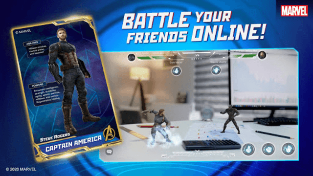
AR Battle Card Experience
Kampanye kartu koleksi AR interaktif yang terinspirasi dari film Black Widow buatan Marvel. Memungkinkan pengguna bertarung secara daring menggunakan kartu fisik.
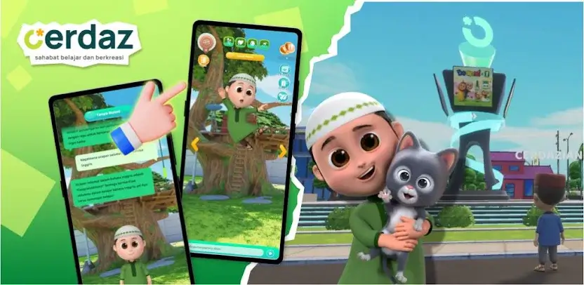
Interactive Character Campaign
Aplikasi pembelajaran berbasis AI & STEAM bersama karakter Nussa dan Rara. Dilengkapi kelas harian, mini-games, dan fitur ramah anak.
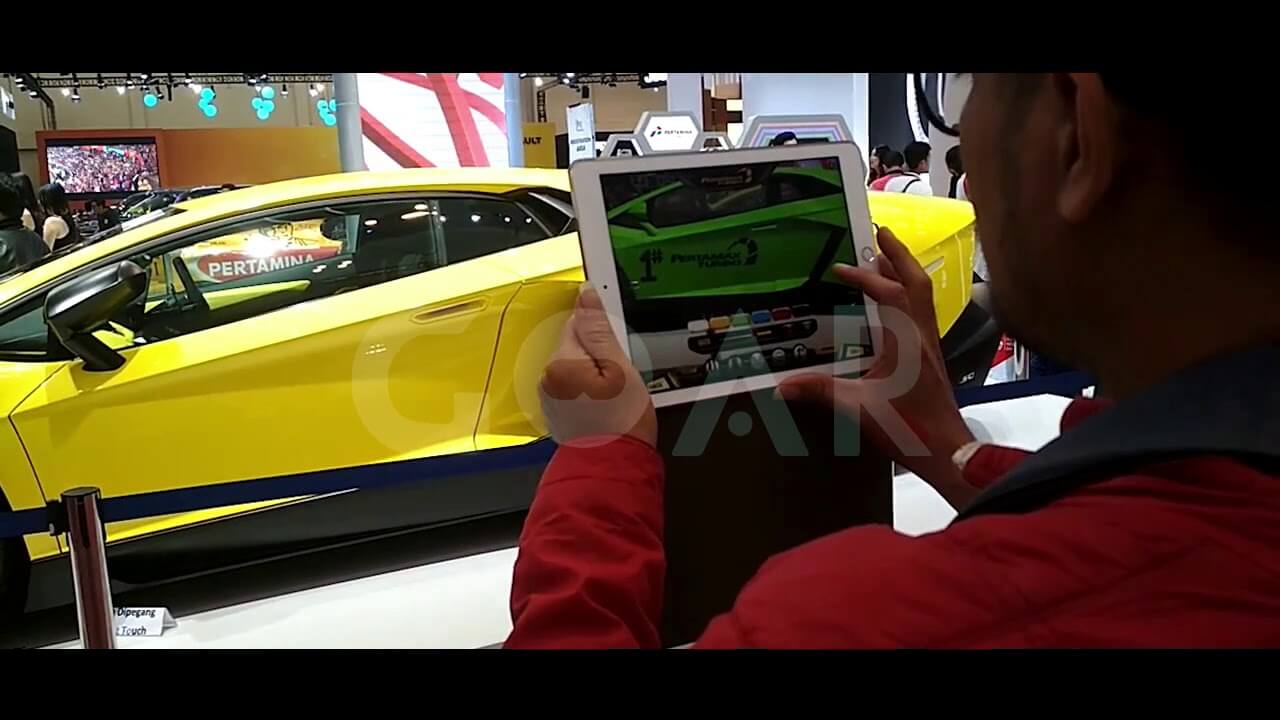
Interactive AR Experience
Aktivitas interaktif pengunjung pameran otomotif GIIAS yang memungkinkan kustomisasi dan modifikasi mobil secara real-time melalui teknologi Augmented Reality.
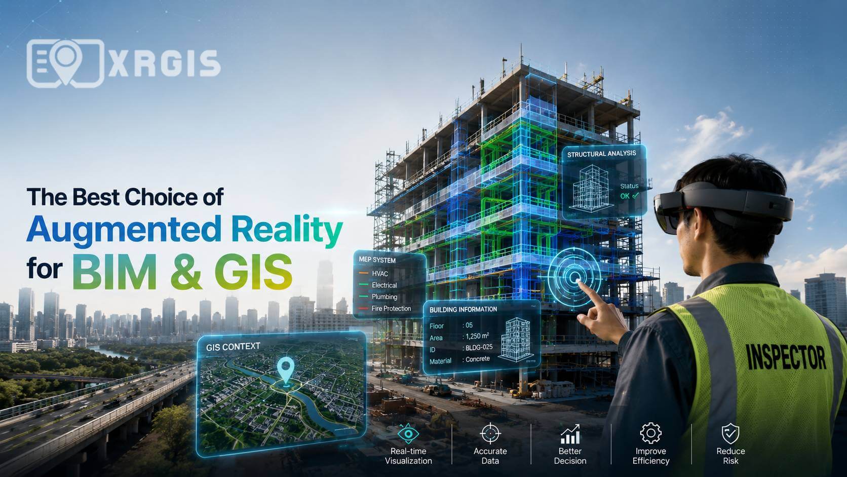
Digital Twin & Smart GIS Platform
Platform visualisasi spasial 3D interaktif yang menyatukan data geografis makro dan data konstruksi mikro (BIM) untuk perencanaan tata kota dan monitoring aset secara terpusat.
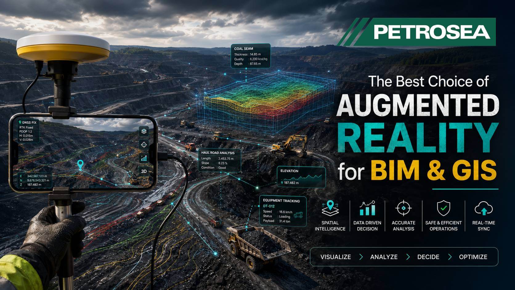
Industrial Digital Visualization
Solusi monitoring operasional pertambangan berbasis digital twin yang menyajikan visualisasi pergerakan alat berat dan elevasi lahan tambang secara real-time.
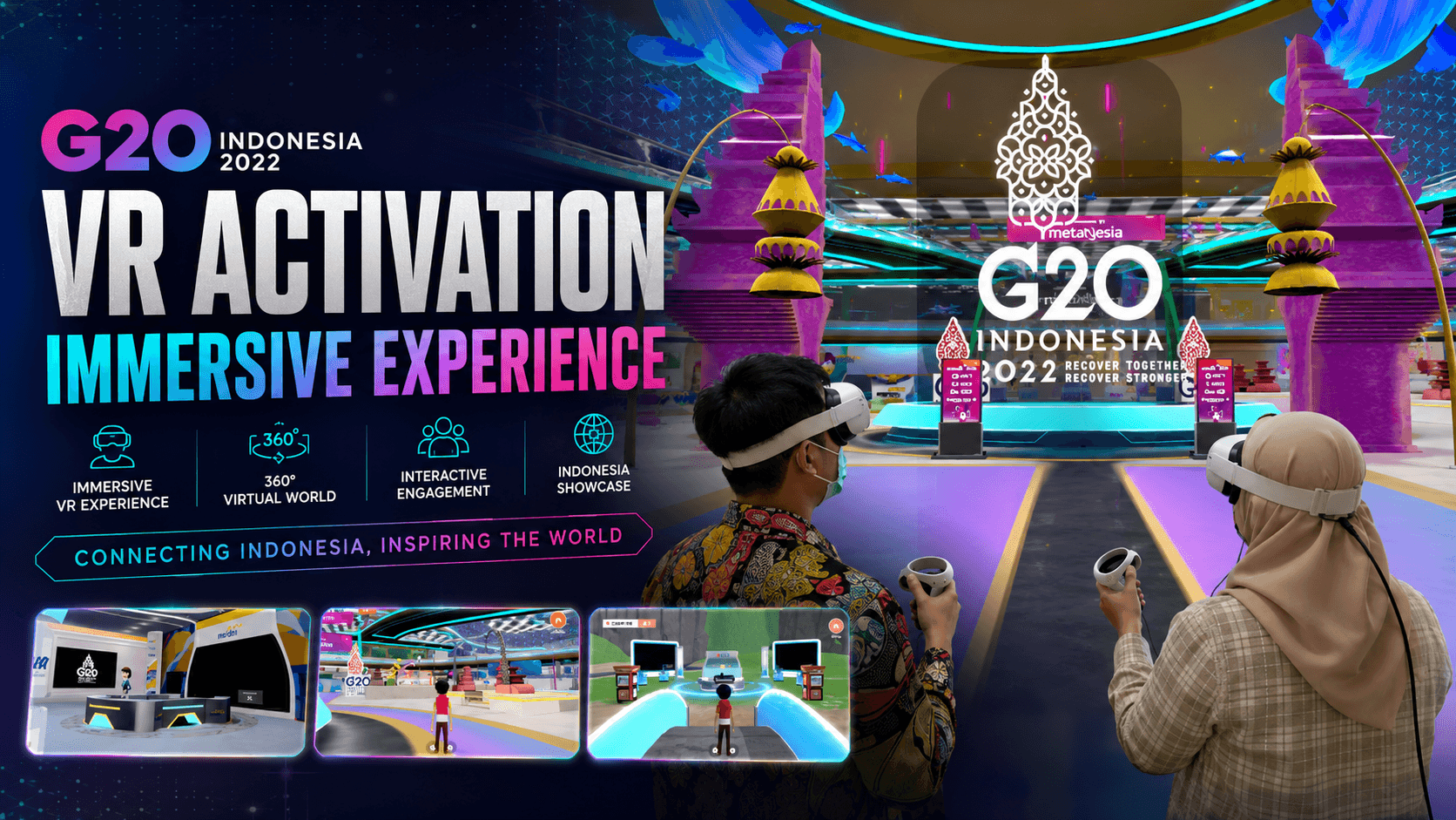
G20 VR Experience
Instalasi virtual reality interaktif pada event kenegaraan G20 untuk mempromosikan digitalisasi infrastruktur Indonesia kepada delegasi internasional.
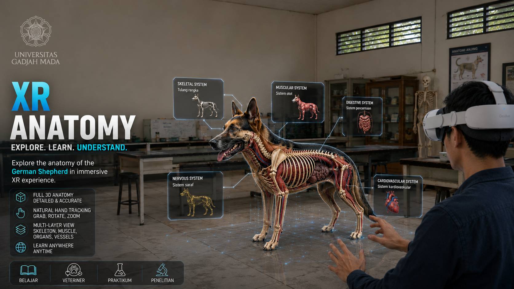
Immersive Learning Experience
Aplikasi laboratorium pembelajaran anatomi hewan interaktif untuk fakultas kedokteran hewan UGM, mempercepat pemahaman organ secara 3D dengan akurasi medis tinggi.
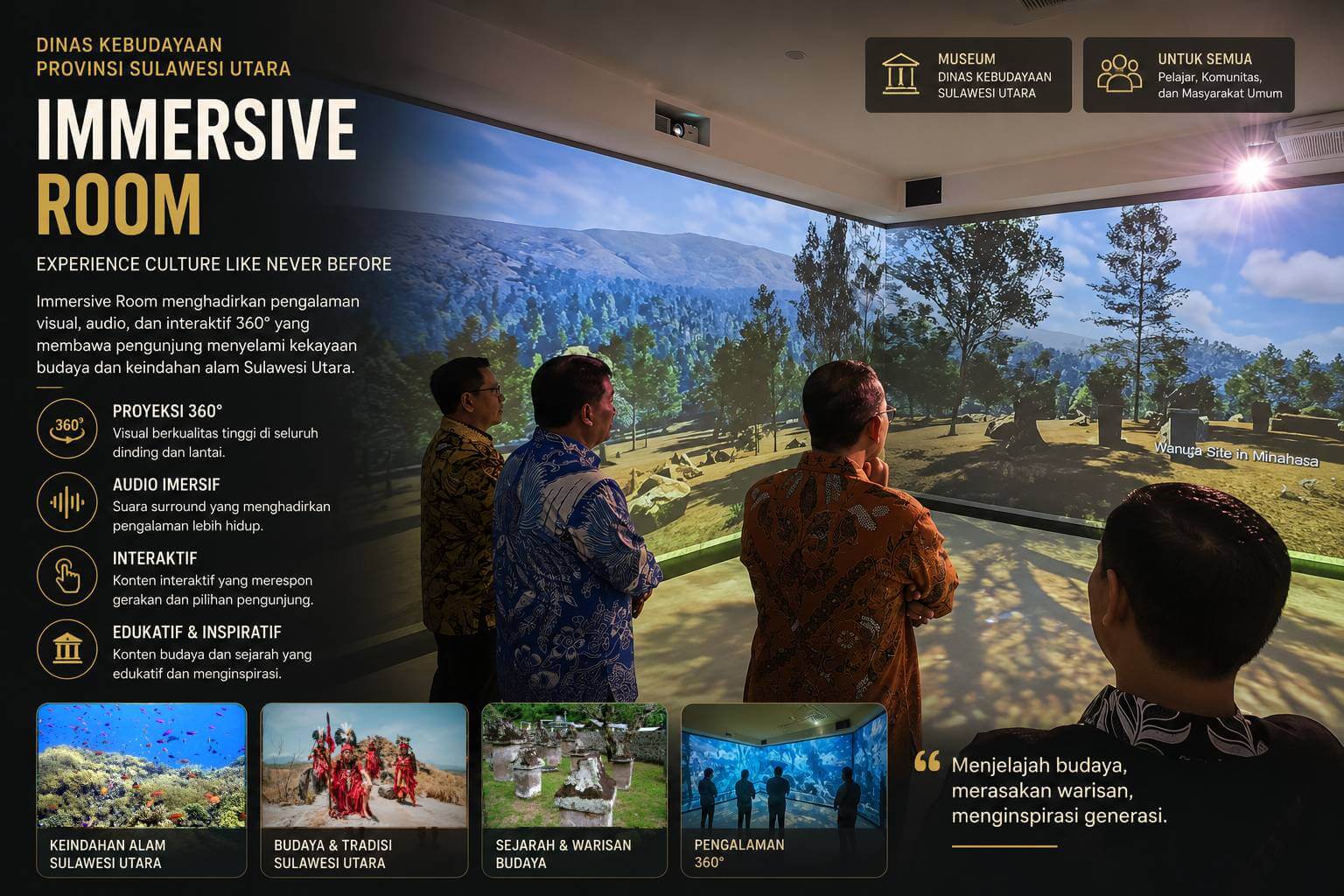
Digital Heritage Experience
Pameran budaya interaktif yang mengubah ruangan museum menjadi pameran imersif dinamis untuk melestarikan dan mengenalkan warisan sejarah Manado.
Alur Kerja Pengembangan Kami
Discovery
Memahami tujuan bisnis, target audiens, serta spesifikasi kebutuhan proyek secara menyeluruh agar menghasilkan solusi yang tepat sasaran.
Consultation & Strategy
Menentukan arsitektur solusi teknologi terbaik, biaya, jangka waktu, dan strategi integrasi agar berjalan sinkron dengan sistem perusahaan Anda.
Design & Prototyping
Pembuatan desain UI/UX, aset 3D awal, wireframe interaktif, dan storyboard agar Anda mendapat gambaran jelas sebelum proses coding dimulai.
Development
Proses perakitan dan pemrograman aplikasi AR, VR, Web3D, AI, atau sensor interaktif dengan standar performa dan optimasi tinggi.
Testing & Deployment
Prosedur Quality Assurance (QA) ketat di berbagai perangkat dan kondisi jaringan untuk memastikan stabilitas sistem, dilanjutkan proses instalasi atau perilisan.
Support & Improvement
Layanan pemeliharaan sistem, pembaruan konten, monitoring kestabilan server secara berkala, dan penambahan fitur kustom jangka panjang.
Telah Dipercaya oleh Pemimpin Industri
Mulai Kembangkan Proyek Anda
Hubungi Kantor Kami
Siap mendiskusikan visi teknologi kreatif Anda menjadi kenyataan.
Grha Savantara, Jl. Anthurium No.1, Ngaglik, Sukoharjo, Sleman, Daerah Istimewa Yogyakarta
+62 857 4758 1969